The Metro Vancouver Walkability Index (VWI) was developed at the University of British Columbia using parcel-level land use data from the British Columbia Assessment Authority, street network data from CanMap, and census data from Statistics Canada, all integrated within a Geographic Information System (GIS). The VWI is a high-resolution spatial database used to measure walkability and quantify physical urban environment features across neighbourhoods in the Metro Vancouver region. The index’s composite walkability score, for example, provides a relative value that varies from -7.5 in the least walkable areas up to as high as 12.0 for the region’s most compact and walkable neighbourhoods.
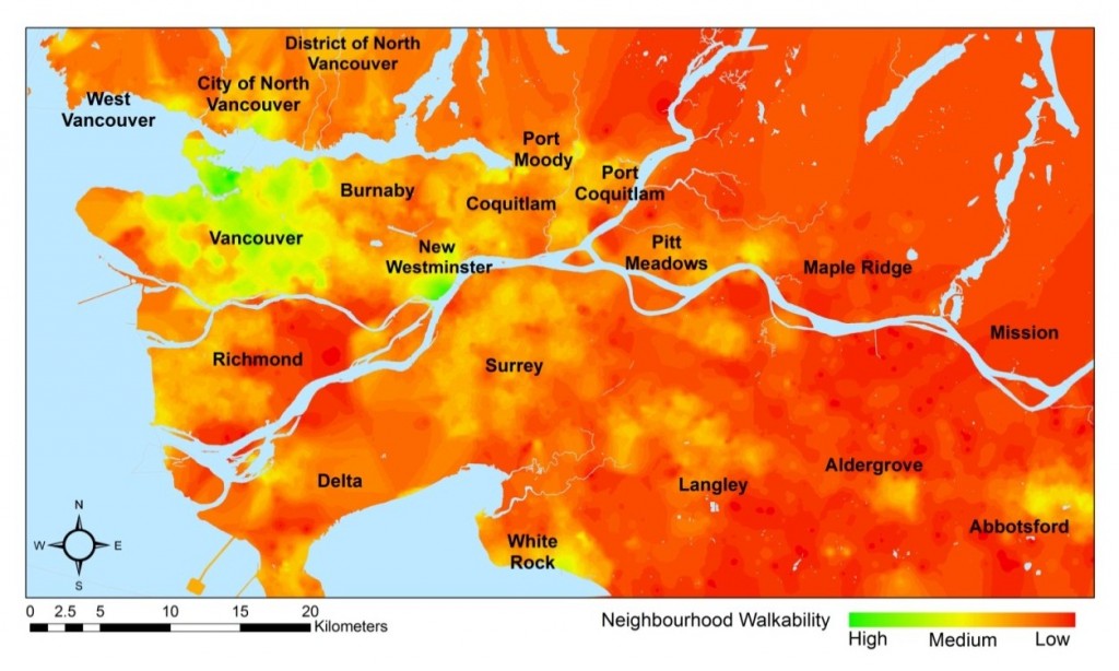
The figure below, the Metro Vancouver Walkability Surface, illustrates the spatial distribution of walkability levels throughout the region using data from the Metro Vancouver Walkability Index. Highly walkable neighbourhoods appear in green, moderately walkable neighbourhoods in shades from yellow to orange, and the least walkable neighbourhoods are coloured red. High walkability levels emerge in many distinct but geographically separate areas, and there is considerable variation in walkability levels within each municipality.
Walkability Surface. A map of walkability index values for all of Metro Vancouver in 2005.
Highly walkable areas
Highly walkable neighbourhoods generally have a more compact urban form characterized by medium to high residential densities, a concentration of nearby commercial (retail) uses, a functional mixing of land uses, and a high degree of connectivity (i.e. small block sizes, higher number of intersections). These characteristics suggest that overall walkability of a street or neighbourhood is the product of a collective effect of density, connectivity, and land use mix. Highly walkable neighbourhoods in the region include Downtown New Westminster, the Waterfront in White Rock, and Ambleside in West Vancouver.
Moderately walkable areas
As measured neighbourhood walkability decreases, so to does the presence of relatively higher residential densities, mixing of land uses and a more direct and connected grid street pattern. The built environment characteristics of Metrotown in Burnaby, Steveston in Richmond, and parts of Nicomekl in Langley City are all illustrative of moderately walkable areas in Metro Vancouver.
Least walkable areas
Least walkable neighbourhoods tend to be generally designed as automobile-oriented with low residential density (predominantly single-family homes), a low degree of connectivity (large block sizes, cul-de-sacs, inconsistent street pattern), and a generally homogenous land use mix and pattern (i.e. residential areas are separated from commercial areas are separated from office areas are separated from recreational areas).
For more information, see the full report: Neighbourhood Design, Travel, and Health in Metro Vancouver: Using a Walkability Index – Executive Summary (October 2010).

