Research Team: Andrew Devlin (MA Candidate, UBC’s Institute for Resources, Environment and Sustainability) and Dr. Lawrence Frank, with support from Josh van Loon (PhD Candidate, UBC’s School of Community and Regional Planning).
Funding: British Columbia Recreation and Parks Association and the Bombardier Foundation.
Prepared for the British Columbia Recreation and Parks Assoication.
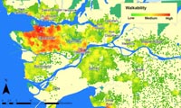
This report represents the first known effort to quantify relationships between a range of neighborhood scale walkability measures and travel behaviour in British Columbia, with a specific focus on Metro Vancouver. The study’s primary aim is to understand how the planning, layout and design of neighbourhoods and communities throughout the region relate to the amount of driving, walking, and transit riding residents do on a daily basis. Unique to this report is the specific analysis of linkages between active transportation and the presence of parks and open space within an individual’s neighbourhood. Notable findings include:
- Adults living in the top 25% most walkable areas in Metro Vancouver were between 2 and 3 times more likely to walk or take transit for any home-based trip compared to those in the least walkable neighbourhoods;
- Residing in a neighbourhood with nearby parks and open spaces doubled the chances of an adult walking for a home-based discretionary trip (i.e. shopping, recreation);
- Adults living in the top 25% most walkable neighbourhoods drive approximately 58% less than those in more auto-oriented areas.
Findings from this report are currently being used by officials at the City of Vancouver to inform the development of a land use policy plan for the Cambie Corridor between 16th Avenue and the Fraser River. The plan will focus on opportunities to integrate development with transit along and around the Canada Line to support the City’s goals of environmental sustainability, livability, and affordability.
To download the final report, click here.

